
How an Ancient Saharan Civilization Thrived in the Dry Sahara Desert
The Sahara Desert today is a symbol of extreme aridity—searing heat, vanishingly rare rainfall, and vast stretches of barren rock and sand. Yet between about 400 BCE and 400 CE, the Garamantes carved out an urban civilization in what is now southwestern Libya, using sophisticated groundwater engineering to turn part of the “empty” desert into a productive landscape. Drawing on new hydrologic research presented at the Geological Society of America’s GSA Connects 2023 meeting, scientists are now piecing together how this civilization thrived for centuries on hidden water—and why their apparent success contained the seeds of inevitable collapse.
Mission Overview: Reconstructing a Desert Civilization
Reconstructing how the Garamantes lived is a multidisciplinary “mission” that blends archaeology, geology, climatology, and modern water science. Archaeological excavations reveal cities, forts, cemeteries, and irrigated fields; satellite imagery illuminates vast subterranean tunnel networks; and hydrologic modeling helps determine how such a system could function in a region with almost no modern rainfall.
According to work led by hydrogeologist Frank Schwartz of The Ohio State University, the Garamantes were uniquely positioned—both geographically and historically—to exploit aquifers that had been filled thousands of years earlier, when the Sahara was greener and wetter. Their achievement was not only social and political; it was fundamentally technological and hydrogeologic.
“The Garamantes show us how far you can push a water resource in an extreme environment—and what happens when you push it too far,” notes Frank Schwartz, Professor of Earth Sciences at Ohio State University.
Understanding their story is more than an archaeological curiosity. It offers a sharp, data-backed parable for today’s rapidly warming, increasingly water-stressed world.
From Green Sahara to Hyper-Arid Desert
To understand the Garamantes’ water strategy, we first need to understand that the Sahara has not always been as dry as it is today. Between roughly 11,000 and 5,000 years ago, the region experienced the “African Humid Period,” when a stronger West African monsoon brought abundant rainfall northward. Lakes, wetlands, and savannas spread across what is now desert, supporting wildlife and human communities.
Around 5,000 years ago, orbital changes weakened the monsoon, and the Sahara transitioned back to hyper-arid conditions. Surface water bodies shrank or vanished, and people migrated toward more reliable river systems such as the Nile or toward Mediterranean coastal zones. Only in a few favorable geological pockets could any significant groundwater remain accessible.
The southwestern Libyan desert—home of the future Garamantes—was one of those pockets. There, ancient rainfall had percolated into underlying rock formations, creating aquifers of so-called “fossil groundwater”: water that accumulated under past climates and receives little to no modern recharge.
The Rise of the Garamantian Empire
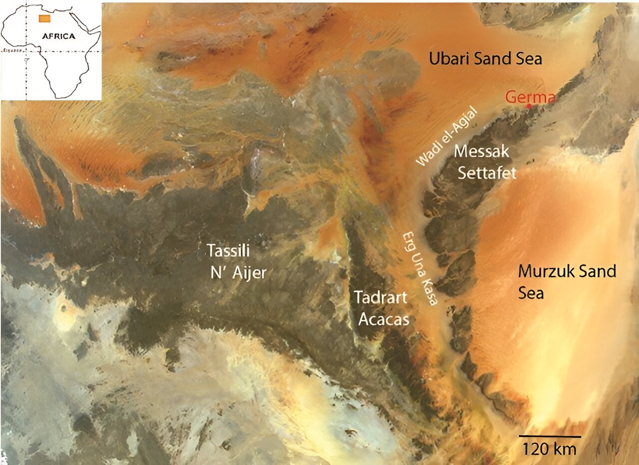
The Garamantes emerged as a regional power around 400 BCE, building walled settlements, irrigated fields, and a complex social hierarchy in the Fezzan region of present-day Libya. They became a key player in north–south trans-Saharan trade networks, moving gold, slaves, ivory, and other goods between sub-Saharan Africa and Mediterranean powers like Rome.
Key Characteristics of Garamantian Society
- Urban centers: Archaeological evidence points to towns with hundreds to thousands of residents, defensive structures, and planned street layouts.
- Intensive agriculture: Date palms, cereals, and other crops were cultivated using irrigation in otherwise barren valleys (wadis).
- Trade connectivity: Camel caravans linked the Garamantes to Carthage, Roman North Africa, and sub-Saharan communities.
- Technological adaptation: The most striking innovation was their adoption of underground water channels—foggara—adapted from qanat technology developed in ancient Persia.
The historian Herodotus mentioned a “very great nation of the Garamantes” who “hunted the Ethiopian troglodytes with four-horse chariots,” a likely exaggeration but a sign that Mediterranean observers recognized their power.
The crucial question has long been: How did they sustain such a society in a place without rivers or reliable rain? The answer lies in their remarkable water infrastructure.
Technology: Foggara and the Engineering of Hidden Water
The Garamantes’ core technological achievement was the construction of an extensive network of underground tunnels known locally as foggara, closely related to the qanat systems used in Iran and surrounding regions. These systems are passive—powered only by gravity—and exquisitely adapted to hot, dry landscapes.
How Foggara Systems Worked
- Siting the tunnel: Engineers identified a gently sloping hillside above an aquifer where the water table lay close enough to the surface to be tapped.
- Digging a master tunnel: A horizontal tunnel was excavated along the slope, just below the water table. The tunnel was only large enough for a person to work inside.
- Vertical shafts: At regular intervals, workers dug vertical access shafts from the surface down to the tunnel, providing ventilation, spoil removal, and maintenance access.
- Gravity-driven flow: Groundwater seeped into the tunnel and flowed gently downhill toward its outlet, where it was directed into open channels or small reservoirs for irrigation and domestic use.
In the Garamantian core region, researchers estimate a cumulative foggara length of about 750 km, with hundreds of vertical shafts. Construction activity peaked between ~100 BCE and 100 CE, aligning with the period of maximum Garamantian expansion.
“Their qanats shouldn’t have actually worked, because the ones in Persia have annual water recharge from snowmelt, and there was zero recharge here,” explains Schwartz. “The system was, in effect, a beautifully engineered straw into a non-renewable water bank.”
Foggara were more than simple wells. By shielding water in subterranean galleries, they:
- Minimized evaporation in the intense Saharan heat.
- Allowed water to be transported over kilometers without pumps.
- Spread water gently over fields, reducing erosion and salinization.
- Provided a stable, year-round supply—until the aquifer declined.
For modern readers interested in traditional water engineering, accessible overviews of qanat systems can be found in research-oriented works such as: “Qanats of Afghanistan: Technology, Transformation and Development” , which discusses similar underground irrigation systems in another arid region.
Hydrogeologic Foundations: Why the System Worked—for a While
For foggara to function, the underlying geology and topography must align precisely. Schwartz’s hydrologic analysis integrates satellite data, field geology, and models of groundwater flow to explain why the Garamantian system was viable for nearly a millennium.
Key Environmental Factors
- Ancient recharge: During the African Humid Period, substantial rainfall recharged buried aquifers. Although recharge essentially stopped later, vast stores of “fossil” water remained.
- Favorable topography: Gently sloping uplands and valleys enabled foggara to intersect the water table at higher elevations and then carry water downslope by gravity.
- Permeable formations: The presence of porous sandstones and fractured rock allowed sufficient groundwater flow into the tunnels.
- Confined settings: In some places, groundwater was trapped under less permeable layers, preserving it from evaporation and limiting natural discharge.
In effect, the Garamantes inherited a giant, finite water reservoir preloaded by ancient climate conditions. Their technology accessed this storehouse with remarkable efficiency—and, crucially, without any built-in feedback that would signal when it was being drained unsustainably.
From a modern water-management perspective, the Garamantes were operating a large, unmonitored overdraft on a fossil aquifer—a scenario increasingly familiar in 21st-century agriculture.
The lack of modern recharge meant that once groundwater levels declined below the tunnel floors, flow would slow and eventually cease. Unlike river irrigation systems that offer immediate visual cues of drought, a foggara system can appear stable for centuries, then fail relatively abruptly from the standpoint of a civilization’s lifespan.
Scientific Significance: Garamantes as a Natural Experiment
For scientists today, the Garamantian case functions as a natural experiment in long-term groundwater exploitation under hyper-arid conditions. It allows researchers to test models of aquifer depletion, settlement dynamics, and climate resilience over many centuries.
Why the Garamantes Matter to Modern Science
- Groundwater sustainability: Their history provides a concrete, archaeologically documented example of a society exceeding the sustainable yield of a fossil aquifer.
- Coupled human–water systems: The rise and fall of the Garamantes show how social complexity, trade, and technology can depend on a single, vulnerable environmental variable: water availability.
- Climate analogs: Many regions today—such as parts of the Middle East, North Africa, and the U.S. Southwest—are transitioning toward drier conditions while drawing heavily on groundwater, making the Garamantian story directly relevant.
- Remote sensing and archaeology: Satellite-based techniques used to map foggara and abandoned fields showcase how modern technologies can uncover the infrastructure of “lost” civilizations in remote deserts.
Articles in journals like Quaternary International and Journal of Arid Environments increasingly reference the Garamantes as a case study in deep-time water management, highlighting how geoscience and archaeology complement each other.
For readers who want a broader context on ancient water engineering and desert civilizations, a more general-audience resource such as “Water Technology in the Ancient World” can be a useful complement, putting the Garamantian case alongside Egyptian, Mesopotamian, and Persian innovations.
Milestones in Garamantian Development
Although precise dates are still debated, the Garamantian trajectory can be sketched in terms of key milestones, each tied to water availability and infrastructure expansion.
Timeline of a Desert Power
- c. 1000–500 BCE – Pre-urban phase: Semi-sedentary communities exploit shallow groundwater and small oases; early experimentation with irrigation is possible.
- c. 400 BCE – Urban emergence: Consolidation of power in the Fezzan; early foggara construction begins as demand grows beyond natural springs.
- 100 BCE–100 CE – Infrastructure boom: Peak foggara building, with hundreds of kilometers of tunnels and shafts; agricultural surplus supports larger towns and intensified trade with Roman North Africa.
- 2nd–3rd centuries CE – Maturity and stress: Continued occupation and trade, but signs of strain likely emerge as water tables slowly decline.
- c. 400 CE and after – Contraction and abandonment: Progressive failure of foggara as aquifers drop below tunnel levels; settlements are abandoned or shrink drastically, marking the effective end of the Garamantian Empire.
The Garamantian story is not one of sudden catastrophe, but of slow, invisible decline in a critical resource, culminating in a tipping point that their engineering could not overcome.
Challenges: Living on a Finite Water Bank
The central challenge for the Garamantes was that their water source was effectively non-renewable on human timescales. Unlike qanat systems in Iran that are replenished by seasonal snowmelt in nearby mountains, the Saharan aquifers received negligible modern recharge.
Internal Vulnerabilities
- Over-reliance on a single resource: Urban centers, agriculture, and trade all depended on foggara-fed irrigation. There was little diversification in water supply.
- Invisibility of depletion: Groundwater decline is gradual and largely unseen until wells run dry or flows diminish sharply.
- High maintenance cost: Tunnels and shafts required continuous upkeep; as water levels fell, deeper and more expensive works would be needed.
- Population and agricultural expansion: Success encouraged growth, which in turn increased water demand, amplifying stress on the aquifer.
External Stressors
- Climatic stability at low rainfall: A consistently dry climate meant there were no “recharge windfalls” to reset the system.
- Shifting trade routes: Changes in Mediterranean and sub-Saharan political economies may have altered trade flows, reducing resources available for infrastructure maintenance.
- Regional conflict and raiding: As in many frontier zones, insecurity can disrupt the labor and coordination needed to service extensive underground networks.
“As you look at modern examples like the San Joaquin Valley, people are using the groundwater up at a faster rate than it's being replenished,” Schwartz notes. “If the propensity for drier years continues, California will ultimately run into the same problem as the Garamantians.”
His comparison brings the Garamantian experience into sharp focus for modern policy debates: overdrafting aquifers today can recreate, at industrial scale, the same vulnerabilities that ended a desert empire 1,600 years ago.
Modern Parallels: Lessons for Today’s Water-Stressed Regions
The Garamantes are increasingly cited in discussions about groundwater depletion in places such as:
- California’s Central Valley (USA): Intensive pumping for agriculture has lowered groundwater levels, causing land subsidence and threatening long-term water security.
- Iran and the Middle East: Qanat systems and wells in some regions are drying as extraction outpaces recharge, prompting migration and economic strain.
- North Africa and the Sahel: Fossil aquifers like the Nubian Sandstone Aquifer System are being tapped for megaprojects, raising questions about intergenerational equity.
Sustainable water management frameworks emphasize:
- Monitoring: Systematic measurement of groundwater levels using wells, satellite gravity data (e.g., NASA GRACE), and modeling.
- Balancing withdrawals and recharge: Where recharge exists, withdrawals should not exceed long-term averages; in fossil aquifers, use must be carefully limited and time-bounded.
- Demand management: Efficient irrigation (drip systems), crop choice tailored to local hydrology, and pricing or regulation to curb overuse.
- Institutional governance: Laws, treaties, and local water-user associations that manage aquifers as shared, finite commons rather than open-access resources.
For a deeper dive into modern groundwater challenges, readers might explore educational content such as the United Nations’ groundwater fact sheets or video lectures from institutions like MIT and UC Davis available on YouTube.
Tools and Technologies: Learning From the Past With Modern Instruments
While the Garamantes relied on camel-borne trade and hand tools, contemporary water scientists have access to satellite sensors, drones, data loggers, and numerical models that can track every stage of the hydrologic cycle. For students, practitioners, or enthusiasts, robust tools can make groundwater data more transparent and actionable.
Practical Resources for Groundwater and Climate Monitoring
- Field water testing: Portable kits, such as the HM Digital TDS-4 Pocket Size TDS Tester Meter , help measure total dissolved solids in wells and springs, providing a quick window into water quality and salinity.
- Environmental sensing: Weather stations and soil-moisture sensors (including DIY kits based on Arduino or Raspberry Pi) allow farmers and researchers to optimize irrigation and track microclimate shifts.
- Technical references: Texts like “Applied Hydrogeology” by C.W. Fetter are standard references for understanding aquifer behavior, well design, and groundwater modeling, giving a scientific framework to the kinds of processes that shaped Garamantian history.
Leveraging such tools does not guarantee sustainability, but it dramatically improves our ability to see problems developing—something the Garamantes, working in the dark of underground tunnels, could not do.
Conclusion: The Garamantian Warning for a Thirsty Century
The Garamantian Empire offers a powerful, empirically grounded example of how human ingenuity can temporarily overcome extreme environmental constraints. Their foggara tunnels, dug by hand over hundreds of kilometers, demonstrate deep practical understanding of groundwater flow, geology, and gravity-driven transport. For nearly a thousand years, that ingenuity sustained an urban civilization in one of the harshest regions on Earth.
Yet their ultimate collapse underscores a harder truth: even the most ingenious technology cannot permanently outrun the limits of a finite resource. When the fossil groundwater that powered their society fell below the reach of their tunnels, no amount of maintenance or incremental extension could save the system. The Garamantes had spent down their natural capital with no viable plan for replacement.
Their story is a cautionary mirror for modern societies—reminding us that invisible depletion feels like stability until it is suddenly, irreversibly not.
As climate change amplifies droughts and heat extremes, and as groundwater extraction accelerates globally, the Garamantes’ experience should push policymakers, engineers, and citizens to ask hard questions about how we value and manage the water beneath our feet. The past cannot provide ready-made policies, but it can clarify the stakes: civilizations, ancient or modern, stand or fall on how they treat their aquifers.
Additional Context and Further Reading
For readers who wish to explore the Garamantes and Saharan paleoclimate in greater depth, consider the following types of resources:
Popular and Academic Overviews
- Phys.org coverage of Schwartz’s presentation at GSA Connects 2023 , which synthesizes the hydrologic and archaeological findings discussed here.
- Scholarly work by archaeologist David Mattingly and colleagues on the Garamantes, including surveys and excavations in the Libyan Fezzan (often summarized in accessible formats on university and museum websites).
- The Geological Society of America’s meeting archives, which frequently host sessions on ancient climate, groundwater, and human adaptation.
Broader Climate and Water Resources Context
- The Intergovernmental Panel on Climate Change (IPCC) Working Group II reports, especially sections on water resources and semi-arid regions: https://www.ipcc.ch/report/ar6/wg2/.
- United Nations World Water Development Reports: https://www.unesco.org/en/wwap/wwdr.
- Educational videos on the African Humid Period and Sahara’s climate history, for instance lectures by paleoclimatologists hosted on YouTube.
By integrating archaeological evidence with state-of-the-art hydrology, the Garamantes’ story transforms from a distant curiosity into a rigorous case study in long-term resource use. It is both a testament to human ingenuity and a stark warning: for any society built on finite water, the real question is not whether limits exist, but whether we choose to recognize them in time.
References / Sources
- Phys.org – “How an ancient Saharan civilization harnessed groundwater to thrive in the dry Sahara Desert (GSA Connects 2023)”: https://phys.org/news/2023-10-ancient-saharan-civilization-groundwater-sahara.html
- Geological Society of America – GSA Connects meeting program: https://gsa.confex.com/
- UNESCO – Groundwater Overview: https://www.unwater.org/water-facts/groundwater
- IPCC AR6 Working Group II – Impacts, Adaptation and Vulnerability: https://www.ipcc.ch/report/ar6/wg2/
- Wikimedia Commons image sources cited in captions for Libyan desert, oases, qanats, and San Joaquin Valley (all accessed 2025).
